


Official maps can be used to preserve trail easements and rights-of-way.
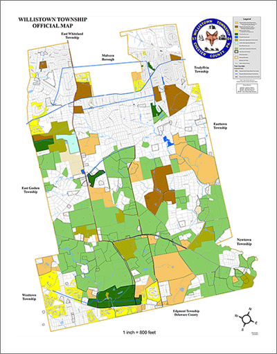
The Willistown Township Official Map shows both preserved open space and properties proposed for conservation.
How it Works
Article IV of the PA Municipalities Planning Code (MPC) authorizes municipalities to adopt official maps, designating areas of interest for possible future right of ways, like roads or trails, or public grounds, such as parks or flood control areas. The adoption of an official map by ordinance does not, in and of itself, constitute an active acquisition of property rights. Instead, it is a notification of the municipality's future intent to possibly do so. The official map assists the municipality to effectively prioritize its acquisition needs, enabling it to focus its resources on properties that are most important to the community. An official map is not a municipal base map, an existing or future land use map, a zoning map, or any map in a comprehensive plan.
Benefits
Long Range Planning
Official maps inform property owners and developers of long-range municipal goals and intentions before they make development plans, and positions municipalities and private parties to work cooperatively.
Public-Private Relations
The clarity of the official map creates an atmosphere where municipal officials and developers can discuss what is necessary to meet their respective needs. In addition, the official map puts the plan of the municipal officials on full display, which saves developers from presenting plans, only to find out the municipality has other plans for the land.
Managing & Directing Growth
A municipality's official map can play a key role in directing development into planned growth areas, which in turn can provide for land to be designated for parks or open space. The official map increases the likelihood that important conservation resources will be protected.
Future Roadways & Pathways
Establishing bicycle and/or pedestrian pathways and trails is one of the most common applications of the official map. Goals such as improving safety, managing congestion, and improving access to services and facilities can be addressed through the reservation of land for future roadways, bicycle trails, and pedestrian pathways.
Grant Application Support
Applying for state or federal grants is often very competitive, but having an official map can support a municipality's application for funds, because it demonstrates that a municipality has a plan and the technical means to implement it.

West Whiteland has used its official map to extend Waterloo Boulevard, providing better interconnectivity and alternatives for drivers.
Although official maps are often considered tools for preserving transportation infrastructure, they can be used successfully for open space preservation.
Get Started
The governing body of a municipality has the task of determining key aspects of its potential official map, such as the purpose or goals of the official map, establishing a capital improvements budget, assigning responsibility for completion, and reviewing requirements set forth by the Municipalities Planning Code (MPC). Along with setting the purpose of the official map, municipalities must delineate which features they plan on included in their official map. Existing and proposed public streets, street ultimate rights-of-way, public parks, open space reservations, trails, public facilities, and public easements are a few examples of features that should be included on an official map. The official map should use the municipality's comprehensive plan as a guide for which public improvements to designate, and it can cover the whole municipality or only a portion of it.
Once a plan has been devised, a planning consultant will draft the official map utilizing a base map that includes up to date parcel and roadway information. The official map must be accompanied by a written ordinance describing the map and its purpose, define the categories depicted on the map, and how the map is to be applied. The provisions of the MPC in regard to time limitations and effect of the official map should be included. Once completed, the draft map and ordinance must be reviewed by internal and external stakeholders. Requirements for external review are stated in the MPC, and include bodies such as the County Planning Commission, adjacent municipalities, and other boards or bodies within the municipality if requested.
Following proper public notice a public hearing must be held by the governing body before voting on enactment of the map and ordinance. If no changes result from the public hearing, the governing body may proceed with the adoption of the official map and ordinance. If substantial changes are made, an additional public hearing should be held prior to adoption. Once adopted, a copy of the official map and ordinance must be sent to adjacent municipalities, the County Planning Commission, and the County Recorder of Deeds for recording within 60 days of the effective date. Cross references to the official map should be place in the zoning and subdivision and land development ordinance. The official map should become part of the standard review procedure when development plans are submitted. The same goes for issuing building permits to ensure that proposed construction does not encroach on mapped features.
According to PennDOT's guide on official maps, "once a property owner or developer notifies a municipality of their intention to build, subdivide, or perform other work on land that is located on an official map, the municipality has up to a year to confirm its acquisition interest and negotiate to acquire the land. Acquisition can take the form of dedication by owner, purchase of land or easement by the municipality, negotiations with owner/developer to make desired improvements, or eminent domain (although rare), if the municipality chooses."
Considerations
Eminent Domain
A common concern for public officials considering the adoption of an official map appears to be related to the perceived use of eminent domain to secure the public lands necessary to implement the improvements included in the official map. In most cases improvements are negotiated successfully and eminent domain is rarely used and only as a last resort.
Roadways Utilizing Federal Funds
If a municipality targets future improvements on a roadway where federal funds are anticipated to be used for design or construction, the National Environmental Policy Act (NEPA) is triggered.
Reducing Costs
Securing funding for official map implementation has proven to be one of the biggest challenges, but proper negotiations with developers and/or other partners has proven to lessen these costs significantly.
Prioritizing Improvements
It is not always necessary to show all possible improvements on the official map, and many municipalities have found success in limiting the features they include to their highest priority or the most likely to be successfully funded.
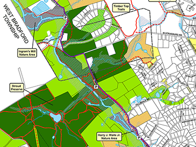
The East Bradford Township Official Map has helped preserve open space, direct growth, and identify trail corridors.
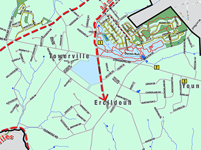
The East Fallowfield Township Official Map focuses on proposed trails.
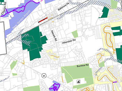
The New Garden Township Official Map shows land to be preserved, future trails, and a future road alignment in Toughkennamon Village.
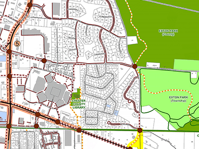
The West Whiteland Township Official Map addresses a wide range of municipal and public needs, such as sidewalks, and includes descriptions of these needs.