

Greenways
A greenway is a corridor of undeveloped land, usually along a stream or ridgeline, which creates a continuous corridor, providing environmental, wildlife habitat, water resources, and possible recreational benefits.
How it Works
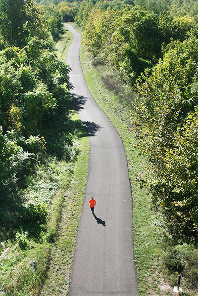
A greenway can be thought of as a string of pearls — where the "string" represents a corridor of undeveloped land and the "pearls" are the resources they connect, like parks, forest patches, or village centers. Greenways often follow naturally-occurring corridors like waterways or ridgelines, but they can also be created through redevelopment. A greenway can also be a trail, a wildlife corridor created from an abandoned railway, utility or other right of way. Rail trails, such as the Chester Valley Trail, are some of the most common forms of greenway.
Benefits
Wildlife Habitat
Greenways provide contiguous habitat, allowing for healthier wildlife and movement and migration of species.
Recreation
Greenways can serve as linear parks or locations for trails- both land and water- providing quality recreation opportunities.
Environmental Benefits
Greenways can provide significant environmental benefits – particularly if they are sited along stream corridors or ridgelines. Such benefits include increased stormwater infiltration, reduced erosion, increased water quality, resource connectivity, and protection of sensitive natural resources.
Quality of Life
Greenways and other open spaces increase quality of life, attract businesses and talented workers to our region, and increase property values.
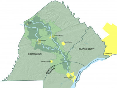
Map source: Brandywine Conservancy.
Get Started
Municipalities have a central role to play in planning for greenways and in implementing their protection. Continuous greenways provide greater benefits than disjointed greenways, so municipalities should take steps to designate these corridors and protect them from fragmentation.
Plan for Greenways
Municipal plans and regulatory ordinances are important for identifying greenways and providing local protection.
Identify Greenways Early: The earlier a greenway is identified and designated within a municipality’s land use plans, the simpler it will be to protect the continuity of the greenway from fragmentation caused by development. Municipalities can plan for the protection of naturally-occurring greenway corridors by including them in their comprehensive plans and official maps, and by conducting greenway-specific studies. Expressing the municipality’s intent to create a greenway through these documents can create a unified vision upon which land use and property acquisition decisions can be made. Regional planning groups can provide an even more comprehensive means of identifying greenways on a larger scale.
Greenway-Friendly Ordinances: Municipal ordinances centered around the protection of natural resources, such as riparian buffers, floodplains, wetlands, and woodlands, can provide significant protection for greenway corridors. Overlay districts can also promote recreation or protect historic or scenic resources that could all contribute to a greenway.
Adopt transfer of development rights ordinances and use this tool to move development away from the greenway to more appropriate locations.
Encourage cluster/open space design in new developments within the Zoning ordinance, and require open space within developments in the Subdivision and Land Development ordinance.
Protect Greenways
The initiatives following initiatives provide additional tools for protecting greenways that can be used in conjunction with the municipal regulatory ordinances described above. Development of a greenway requires a strategy for protecting and reinforcing the greenway, particularly on properties likely to be developed in the future as well as on properties in private ownership. Privately owned properties may not need to be addressed unless public access is desired. For lands that could be developed in the future or where public access is desired, municipalities or other non-profit partners can obtain easements within a proposed greenway or strategically acquiring parcels for green nodes along the greenway.
Integrate Greenways into Development Plans: Greenways that allow for public access can be important and attractive site design features in large development projects. It also presents an opportunity to partner with the private sector to implement the greenway.
Partner with local land conservancies to plan for and implement targeted open space protection.
Establish a local fund for open space preservation, which can be done through an earned income tax or bond issuance.
Leverage funding for open space preservation from Chester County and the State of Pennsylvania to acquire open space easements or property.
Considerations
Purpose of the Greenway
The municipality should decide whether the intent of establishing a greenway is for natural resource protection, connecting natural areas, providing connectivity/recreation, or for any/all of these. The intent will determine the strategy for its development/preservation.
Public Use
The purpose of the greenway will influence whether public access should be permitted and included in the greenway’s design.
Ownership
The owner/operator of the greenway will be responsible for maintenance and monitoring similar to that associated with maintaining a naturalistic park or preserve. If ownership will remain with each private land owner along the greenway, the municipality will have limited control over tree clearing, erosion, and habitat degradation due to invasive species.
Time frame
Greenways can involve the assembly of many parcels to create corridors that can range from several hundred feet to tens of miles long. Accordingly, greenways can take time to establish. A phased approach including the prioritization of certain linkages can help create “small wins” and make bigger impacts within a shorter time frame.
Funding
Greenway creation does not necessarily require the expenditure of public funds. For example, a greenway located along a floodplain for the purpose of flood prevention and protection of the stream corridor can be established through strict standards within the municipal zoning and subdivision and land development ordinance. Consideration should be given to on-going operations and maintenance costs.
Liability
If the greenway includes public access, landowners, whether private citizens or municipalities, may wonder if the greenway increases their liability. Each party should contact a legal professional, but in general, the Pennsylvania Recreational Use of Land and Water Act (RULWA) provides protection for landowners who make their property available to the public for recreation.
Examples
North Coventry Township's zoning ordinance includes overlay districts for natural resource conservation, scenic preservation, ridgeline protection, and historic preservation. Depending on the purpose of the greenway, specific overlay districts that require preservation of the greenway can be applied to a municipality’s zoning map.
Oxford Region Multimunicipal Comprehensive Plan, 2012
The plan includes the Octorara & Mason Dixon Greenway that follows the Region's western area along the Octorara Creek as well as its southern boundary with Maryland, and part of the areas along the Big Elk Creek.
Landscapes3 promotes expanding the countywide network of protected open space through conservation corridors that connect communities to recreational parks, historic resources, trails, and natural areas while protecting stream and wildlife corridors. The corridors are depicted on the Conservation Clusters and Corridors map in the How We Preserve section of the plan.
The Brandywine Creek Greenway is a regional planning initiative of the Brandywine Conservancy, including 27 municipalities in Chester and Delaware counties in Pennsylvania, New Castle County and the City of Wilmington in Delaware. The vision is to create a 40-mile long conservation and recreation corridor along both branches of the Brandywine from the Christina River in the City of Wilmington to the Pennsylvania Highlands in Honey Brook Township. The Brandywine Conservancy worked with these municipalities to identify the extents of the proposed greenway and create an overall strategic plan for its implementation.
East Bradford Township created a guiding vision for the design and development of public improvements through a 1-mile segment of the Plum Run corridor. The plan includes preserving and interpreting natural features and creating an inviting network of community open space.
North Coventry Comprehensive Plan, 2019
The comprehensive plan includes focused recommendations in the areas of recreation/open space/natural resources, connectivity, commercial/economic development, Township services, and future land use.
Kennett Greenway Shared Use Pathway and Trails System Master Plan
Kennett Township's Trails and Sidewalks Committee oversaw the completion of the Kennett Greenway Shared Use Pathway and Trails System Master Plan, which identified an alignment for the proposed 10+-mile greenway corridor and an action plan for implementing the greenway. The committee also advises elected officials to ensure the Greenway is included in any land development proposals that occur along the route of the planned greenway.
Funding
About half of the municipalities in Chester County have established dedicated funds for open space preservation.
Resource Links
The Chester County Planning Commission's Woodlands and Tree Protection webpage has a wide array of information in one location to assist in the protection and expansion of the county's wooded areas, tree canopy, and individual trees wherever they may be located. Specific Information on planting and protecting trees in the urban landscape is also covered.
We Conserve PA has a comprehensive resource library for all things related to greenways.
The Brandywine Conservancy manages the Brandywine Creek Greenway program.
The Pennsylvania Department of Conservation and Natural Resources (DCNR) maintains resources for planning and implementing greenways.