

All Chester County municipalities regulate construction and disturbance in flood-prone areas. When included as part of the zoning ordinance, flood zone protections are generally treated as a zoning overlay as they impact all districts within officially designated floodplain areas.
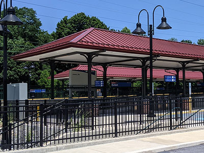
West Whiteland Township has enacted the Rail Transit Overlay District to promote rail transit as an essential component of the Township's overall transportation network in addition to better improving access and amenities at both the Exton and Whitford stations.
How it Works
Zoning overlays are utilized by municipalities to more effectively address special features and other elements of the community deemed important to address municipal goals and to protect health, safety, and general welfare of the community. Zoning overlays are intended to supplement underlying zoning, not supplant it, and can be mandatory or non-mandatory. Mandatory overlays are generally enacted to address features that are distributed throughout a community and need additional regulations to address and protect equitably throughout the municipality (i.e. floodplains, steep slopes, airport approaches, etc.). Non-mandatory overlays generally involve additional uses and/or lot and bulk requirements to encourage defined land use objectives desired by the municipality (i.e. TND, cluster residential, etc.). Municipalities can ensure zoning overlays are appropriately scaled and targeted through implementation of planning goals and through education of the public regarding their benefits and the need for regulation.
Benefits
Targeted Protections
Zoning overlays can be specifically targeted to mitigate unique site characteristics that can be more difficult to address as part of a traditional zoning district. Examples of this include: requiring commercial uses on the first floor of structures in a town center; protecting historic resources that are more scatted-site; restricting uses within a defined radii of a public water well; etc.
Environmental and Natural Resource Protections
Zoning overlays can target defined environmental features (i.e. flood areas, wetlands, woodlands, steep slopes, etc.) to lessen degradation and ensure their continued vitality through additional protection standards.
Historic Preservation
Zoning overlays can forward historical preservation efforts though the provision of lot and bulk standards that reflect the historic land development patterns of the community as well as allow for additional uses in defined historic structures to ensure their ongoing vitality.
Housing Diversity
As all municipalities are required to provide for their fair share of all housing types as part of their zoning ordinances, carefully crafted zoning overlays can provide for appropriate locations to accommodate this need.
Efficient Transportation Systems
Zoning overlays can be designed to ensure adequate rights-of-way are preserved so they are available when needed for additional highway capacity. They can further be established to target other transportation modes such as minimizing obstructions in the vicinity of airports or preserving railroad rights-of-way.
Economic Development
Zoning overlays can further economic development objectives by targeting identified areas as part of municipal planning efforts for development and redevelopment. They can provide for additional uses, design standards, differing lot and bulk standards, etc.
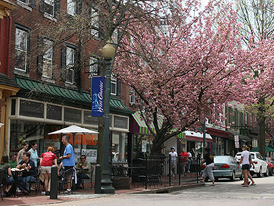
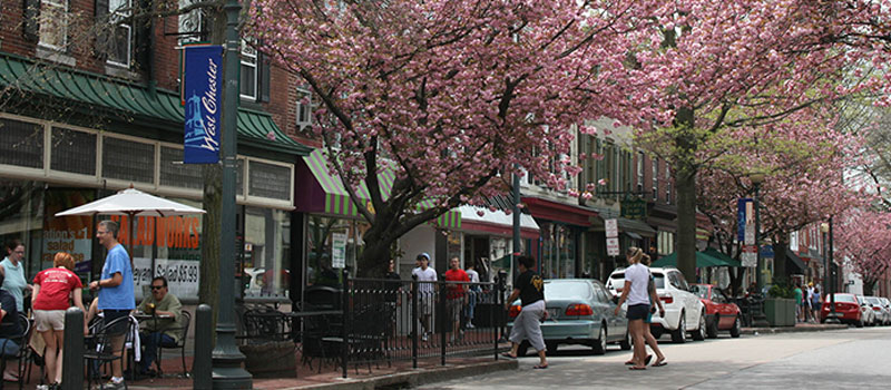
Some municipalities may implement a zoning overlay to encourage defined land uses within specifically targeted areas. In West Chester Borough the Retail Overlay District requires the first 35 feet of the ground floor of all structures within the overlay include retail uses to maintain a vibrant town center of retail uses at the pedestrian scale.
Get Started
Although the Pennsylvania Municipalities Planning Code (MPC) does not specifically define zoning overlays, Section 605 allows for zoning districts to also have "additional classifications." This has broadly been interpreted as allowing municipalities to enact zoning overlays within their jurisdictions.
The first step in the development of a zoning overlay is determining what specifically the overlay will address. Usually the vision and goals outlined in previous planning efforts such as the municipal comprehensive plan can be a starting point for the development of zoning overlays. Overlays can also be proposed for consideration by the municipality from an outside party such as a resident or developer. Ultimately a zoning overlay should further overriding policy goals of the municipality through its implementation.
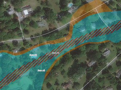
After the determination is made as to what is specifically being addressed, the boundaries and/or extent of the zoning overlay must be determined. These boundaries can encompass areas defined by other agencies (FEMA identified flood zones), be a defined radius from the feature to be protected (isolation distances from public wells, defined buffer from a road centerline, etc.), or apply to targeted features present throughout the municipality (historic resources).
Once boundaries and/or extents have been defined for the overlay, specific ordinance language can be crafted. Depending on what is being addressed, the following elements could be considered when developing and/or amending zoning overlay standards:
Cluster/open space conservation
Cluster residential design preserves open space and directs development away from sensitive areas by allowing clustering of units on smaller lots than permitted in the base zoning district. Cluster designs are generally treated as an overlay, with varying standards based on the underlying zoning district.
Flood Plain Conservation
All Chester County municipalities have in place regulations to protect flood plains and floodways. When found in zoning, these ordinances are overlays that include additional provisions for lands located within flood areas as defined as part of FEMA mapping. The intent of these regulations is to minimize impacts to flood prone areas as well as to minimize property damage associated with flooding.
Natural Resources Conservation
Overlays can be utilized to further protect other natural resources and environmentally sensitive areas such as steep slopes, wetlands, riparian buffers, woodlands, etc. These provisions should target resources deemed of most importance from previous planning efforts and/or serve to mitigate impacts to these resources.
Historic Preservation
Overlays can serve to advance historic preservation goals. How these standards are crafted is dependent on what preservation goals a municipality is seeking to implement. An overlay can apply to resources throughout the municipality and/or defined historic districts.
Mixed-uses and TND
Overlays can be targeted to appropriate areas to encourage development of mixed-use and/or TND communities. These can include incentives to encourage elements such as green buildings, open space, first floor retail, affordably-priced housing units, etc.
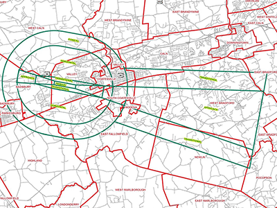
Municipalities located within landing paths of airports must adopt overlays to mitigate the impacts of structures within these areas. In East Fallowfield Township, the Airport District Overlay limits the heights of manmade and natural objects within flightpaths of G.O. Carlson Airport.
Redevelopment Sites
Overlays can allow additional development and uses on brownfield, greyfield, and other redevelopment sites to encourage cleanup of these sites and productive use of these areas.
Scenic and Viewshed Preservation
Overlays can target identified scenic and viewshed resources of community importance.
Telecommunications
Overlays can be developed to specifically encourage collocation of facilities on existing towers and structures as well as reasonably limit where specifically they can be placed.
Wellhead Protection
Overlays can serve to protect locations of wellheads that serve as public water supply sources. These overlays can limit uses within defined radii from wellhead locations to prevent contamination of water supply.
Airport
Overlays can limit heights of structures and mitigate other potential conflicting land uses within a set radius of an airport.
In addition to the zoning ordinance, the subdivision and land development ordinance should also be reviewed to determine if standards are included that sensibly compliment defined zoning overlays. If they do not, amending the subdivision and land development ordinance may be appropriate to incorporate requirements for amenities such as: street and alley design, sidewalks and pedestrian circulation, street trees and landscaping, etc.
Considerations
Compatibility of Allowable Uses
As part of the planning process, consideration should be given to the types of uses permitted as part of the designated overlay. Specifically uses should be targeted that best compliment what specifically the overlay is designed to address.
Underlying Zoning
Before adoption of an overlay zone, an analysis of the underlying zoning could be undertaken to determine if amendments to the underlying zoning district can address what is seeking to be accomplished through the overlay.
Administration and Public Awareness
Zoning overlays may create an additional layer of complexity in the zoning ordinance, which requires municipal staff to be aware of how to interpret these overlays. Educational outreach for the public may be necessary to explain the intricacies of the zoning ordinance and to explain how overlay districts function and impact individual properties.
Non-municipal Driven Overlays
In some circumstances a developer or other non-municipal entity may approach a municipality with a proposed overlay to permit a desired use at a specific location. As these overlays are generally very narrow in both where and what they are designed to address, the municipality should evaluate their existing zoning to determine if it is more appropriate to amend an underlying zoning district or rezone the land rather than create a new, specialized overlay.
Examples
East Fallowfield Township
The Airport District Overlay regulates heights of man-made and natural objects, as well as uses that negatively impact users of the Chester County G. O. Carlson Airport.
Schuylkill Township
The Natural Resource Conservation Overlay District provides protections to a wide variety of natural resources to further goals set in township planning efforts. Resources within this designation include: floodplains, steep slopes, watercourses/riparian buffers, wetlands, groundwater/aquifer recharge areas, and woodlands.

Pennsbury Township
The Route 1 Corridor and Brandywine Battlefield Overlay District provides protections to historic resources and viewsheds associated with the Brandywine Battlefield National Historic Landmark. It further encourages the most appropriate uses of land through the corridor and establishes consistent architectural and design guidelines.
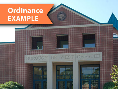
West Chester Borough
The Retail Overlay District is an overlay that requires retail, restaurant, and/or personal service shops be located within a defined area of the first floor frontage in the Town Center District. This furthers borough goals of a vibrant, pedestrian oriented town center area.
Willistown Township
The Paoli Pike Corridor District is an overlay that is designed to both recognize and provide opportunities for further development of businesses along a defined portion of Paoli Pike.