

Chester Valley Trail Project Status
The Chester Valley Trail (CVT) is part of the Circuit Trail network, a planned 800+ mile multi-use trail network throughout greater Philadelphia. The existing CVT runs through the heart of Chester County and is the most heavily used trail within the County Parks system. The CVT begins at the Schuylkill River Trail in Norristown, Montgomery County and currently ends along Commerce Drive in West Whiteland Township, Chester County.

Chester Valley Trail in West Whiteland Township
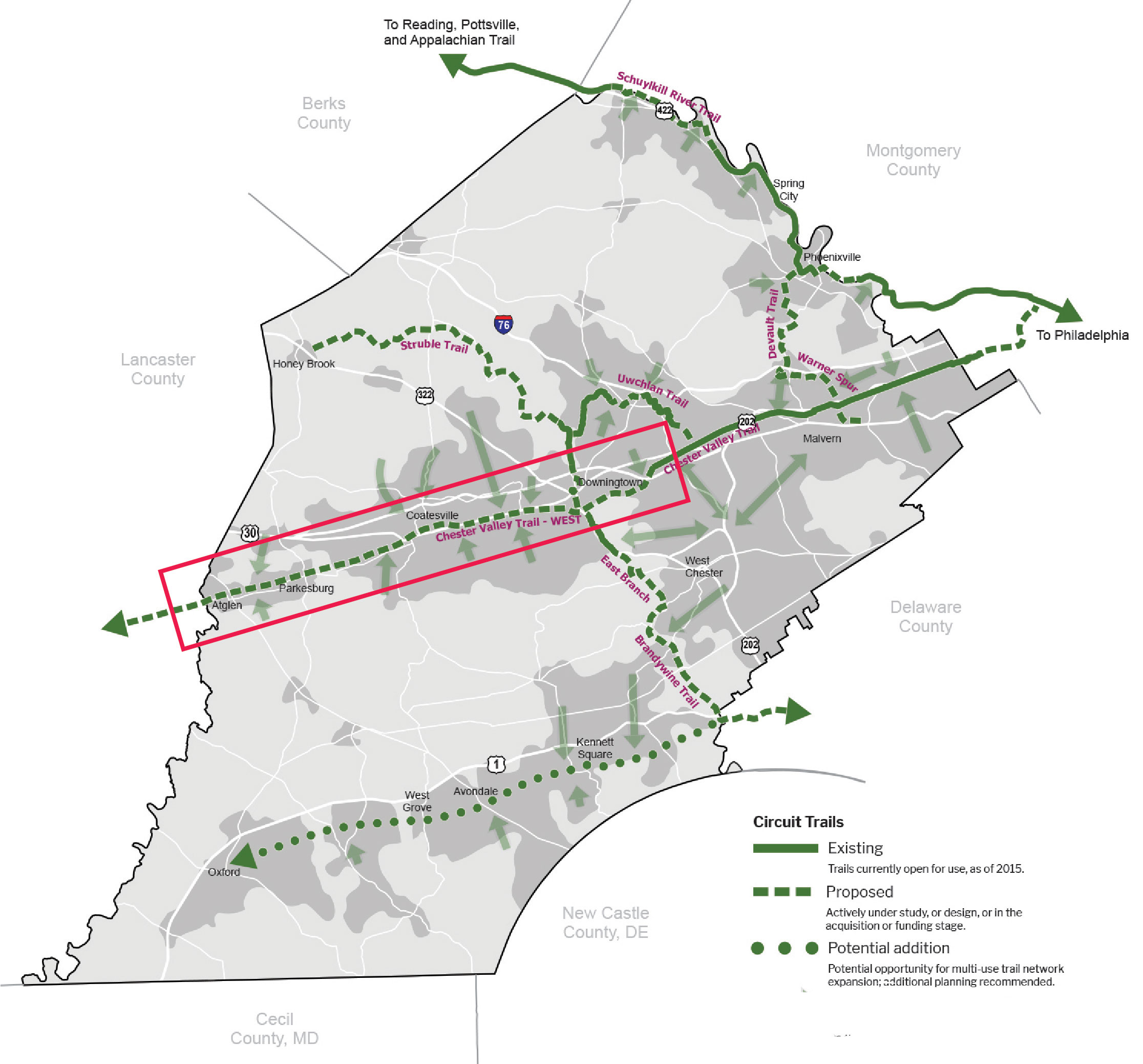
The Chester County Planning Commission developed master plans for the future extension of the trail across Chester County. The corridor consists of four primary segments:
- A Chester Valley Trail Phase IVA Extension to Oaklands (anticipated completion within 5 years)
- B Chester Valley Trail P&T Extension (anticipated completion within 5-10 years)
- C Chester Valley Trail West: Downingtown to Atglen (anticipated completion in 10+ years)
- D Chester Valley Trail West: Enola Low Grade Segment — Extension to Atglen (anticipated completion within 5 years)
Refer to the individual project summaries for more information about each project.
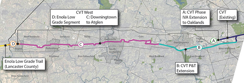
Chester Valley Trail Project Map
A Chester Valley Trail Phase IVA Extension to Oaklands
The CVT Extension to Oaklands project will extend the existing alignment of the Chester Valley Trail approximately 1-mile west from its current terminus along Commerce Drive to the Oaklands Corporate Center. The trail will include a bridge carrying the trail over Whitford Road.
Status/Updates
- Chester County was awarded construction funding from PA DCNR's Community Conservation Partnership Program and DVRPC's Regional Trails Program for construction of CVT Phase IVA. Trail design and engineering is nearly 100% complete.
Schedule/Next Steps
(all timeframes are approximate based on current project understanding and are subject to change)
- Spring 2024: Consultant to complete trail construction documents and bid package preparation.
- Summer 2024: Construction contract to be put out to bid.
- Fall 2024-Summer 2025: Trail construction.
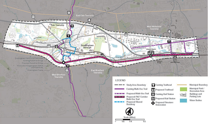
B Chester Valley Trail P&T Extension
Important: The P&T corridor is currently owned by PennDOT and trespassing on the property is expressly prohibited.
In 2017, the Chester County Planning Commission completed the Chester Valley Trail — Extension to Downingtown Feasibility Study and Master Plan to determine a trail alignment to extend the CVT to the Borough of Downingtown. The historic Philadelphia & Thorndale (P&T) Branch rail corridor was identified as the overwhelmingly preferred route, extending the trail 7.4 miles west from Exton, West Whiteland Township through East Bradford Township, East Caln Township, West Bradford Township, Downingtown Borough, and ending near Thorndale in Caln Township.
CVT Extension to Downingtown Master Plan
The P&T was constructed between 1903-1906 by the Pennsylvania Railroad to provide a separated low-grade freight line to bypass the more heavily trafficked Pennsylvania Main Line. Construction of the P&T involved over 2.6 million cubic yards of earthwork and 100,000 cubic yards of masonry for underpasses and culverts to maintain a consistent grade under 2%. The P&T was completely grade-separated from roadways to achieve high speed movement of freight through the corridor.
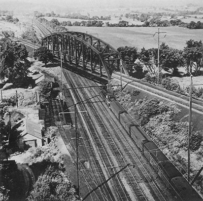
View of the Whitford Truss bridge carrying the P&T over the Pennsylvania Main Line. Credit: Triumph II Philadelphia to Harrisburg 1828-1998
The P&T was active until the late 1980's and the rails were removed in 1992.
The corridor is well-suited for trail development due to its consistent low grade and lack of at-grade road crossings. The corridor contains a very diverse landscape, from deep, canyon-like cuts through hillsides to elevated ridges that provide sweeping vistas of the Chester Valley. The future trail will accommodate a wide range of users, including pedestrians, bicyclists, rollerskaters, cross country skiers, and those using mobility-assist devices like wheelchairs and will be designed to meet current AASHTO Guidelines for the Development of Bicycle Facilities and ADA accessibility requirements.
Phasing
The P&T will be implemented in a phased approach aligned with financial resources and project implementation capacity. Primary project phases have been identified on the Proposed Phasing map, however the phasing order has not been determined with the exception of the first phase.
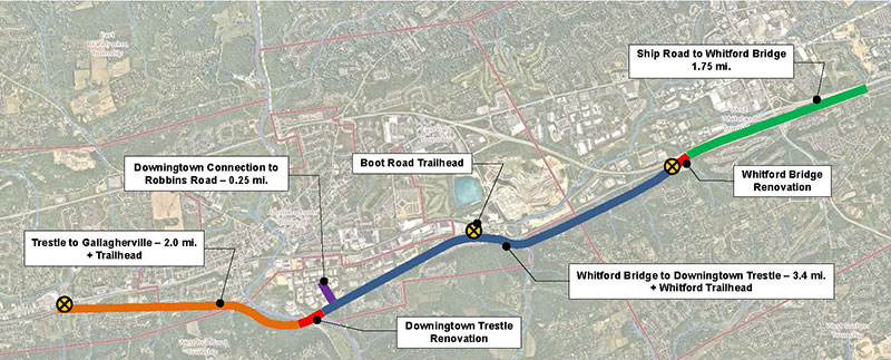
CVT P&T Project Phasing map
- Current Phase: Whitford Bridge to Downingtown Trestle (3.4 miles) + Whitford Trailhead
- Chester County was awarded funding from PA DCNR for the design of Phase I, a 3.4 mile segment between the Whitford Bridge and the Downingtown Trestle Bridge. Improvements will include a 10'-15' wide multi-use trail with graded shoulder transitions, stormwater improvements, and trail amenities like signage and benches. Chester County will pursue development of a trailhead along Boot Road and a connector trail from the P&T to Robbins Road in Downingtown in coordination with this phase.
- Future Phase: Downingtown Trestle Renovation
- Future Phase: Ship Road to Whitford Bridge (1.75 miles)
- Future Phase: Whitford Bridge Renovation
- Future Phase: Downingtown Trestle to Gallagherville (2 miles) + Trailhead

Photo-simulation of P&T trail near Skelp Level Road
Status/Updates
- December 2022: PennDOT acquires P&T corridor from Norfolk Southern.
- March 2023: PennDOT replaces deteriorating netting on underside of Downingtown Trestle bridge.
- October 2023: Chester County is awarded design funding from PA DCNR's Community Conservation Partnerships Program for Phase I.
- November 2023: West Whiteland completes Ship Road couplet that includes a new sidepath along Ship Road connecting the existing CVT to the future eastern terminus of the P&T extension.
- *NEW* January 2024: PennDOT installs additional safety fencing and "No Trespassing" signs at the Downingtown Trestle bridge.
Schedule/Next Steps
(all timeframes are approximate based on current project understanding and are subject to change)
- Spring 2024: Chester County to develop and advertise RFP for Phase I trail design and engineering services and apply for grant funding for the next phase of design.
- Summer/Fall 2024: Chester County to award design contract to selected consultant for Phase I.
- Fall/Winter 2024: PennDOT to complete the property disposition process and transfer ownership to Chester County and SEPTA.
- 2025-2026: Phase I design/engineering and construction documentation.
- 2027-2028: Phase I bidding and trail construction.
Chester Valley Trail West
In 2018, the Chester County Planning Commission completed the Chester Valley Trail West Feasibility Study and Master Plan that identified a preferred alignment for the extension of the CVT from Downingtown to the western county line in West Sadsbury Township, where it will connect with the Enola Low Grade Trail in Lancaster County. The CVT Enola Low Grade Segment will be the first part of the CVT West to be developed as described below.
C Chester Valley Trail West: Downingtown to Atglen
The recommended alignment for the CVT West is over 20 miles long and contains both multi-use trails and on-road connector facilities. This segment is viewed as a long-range objective that will occur after the completion of the Chester Valley Trail P&T extension.
There are no current efforts to advance this section of the trail. Please refer to the Chester Valley Trail West Feasibility Study and Master Plan for more information regarding the proposed plan.
D Chester Valley Trail West: Enola Low Grade Segment — Extension to Atglen
Important: The Enola Low Grade Corridor is owned by SEPTA and trespassing on the property is expressly prohibited.
The CVT Extension to Atglen project will kickoff development of the CVT West. This project will extend the trail from the Chester/Lancaster County border in West Sadsbury Township into Atglen Borough. The trail will be constructed along the historic Enola Low Grade rail corridor currently owned by SEPTA.

Photo-simulation of CVT Enola Low Grade Trail Extension
Status/Updates
- Chester County was awarded design/engineering funding from DVRPC's Regional Trails Program and is in the process of selecting a consultant to perform the work.
- *NEW* March 2024: Chester County is awarded construction funding from DCED's Multimodal Transportation Fund.
Scheduling/Next Steps
(all timeframes are approximate based on current project understanding and are subject to change)
- Spring 2024: Chester County to award design contract to selected consultant.
- Spring 2024-2025: Consultant to develop trail design/engineering construction drawings and specifications.
- 2026: Bidding and trail construction.
For more questions or more information, please contact Steve Buck, CCPC's Trails Planner, at 610-344-6285 or seObfuscationbuck@Obfuscationchesco.org.